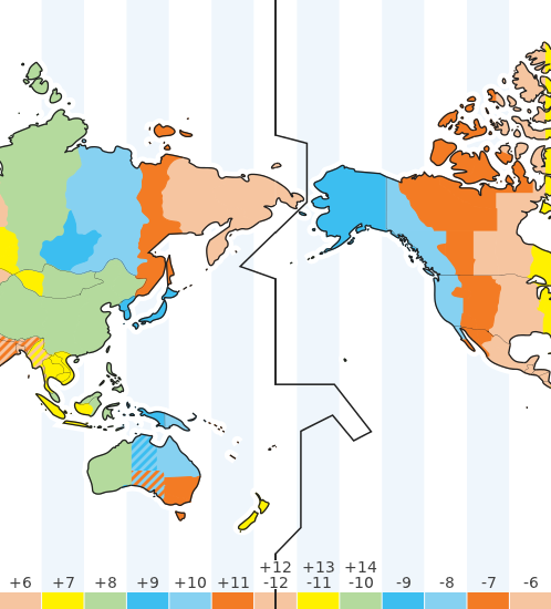
The international date line. Note that the time zones shown are as of January 2012. Go to the Time Zone Map for an up-to-date map showing current time zones and local times.
The International Date Line
The International Date Line (IDL) is an imaginary line of longitude on the Earth’s surface located at about 180 degrees east (or west) of the Greenwich Meridian.The date line is shown as an uneven black vertical line in the Time Zone Map above and marks the divide where the date changes by one day. It makes some deviations from the 180-degree meridian to avoid dividing countries in two, especially in the Polynesia region.
The time difference between either side of the International Date Line is not always exactly 24 hours because of local time zone variations.
Interactive Time Zone Map
If you travel around the world, changing standard time by one hour each time you enter a new time zone, then a complete circuit would mean that you adjusted your clock or watch time by 24 hours. This would lead to a difference of one day between the date on your clock and the real calendar date. To avoid this, countries are on either side of the International Date Line which runs down the middle of the Pacific Ocean. If you cross the date line moving east, you subtract a day, whereas if you are moving west you add a day.
While the world is divided into 24 time zones, there has to be a place where there is a difference in days, somewhere the day truly "starts" on the planet. Thus, the 180° line of longitude, exactly one-half way around the planet from Greenwich, England and 0° longitude is approximately where the International Date Line is located. Cross the line from the east to the west and a day is added. Cross from west to the east and a day is subtracted.
Without the International Date Line, people who travel west around the planet would discover that when they returned home, it would seem as though an extra day had passed. This situation actually happened to Magellan's crew when they returned home after their circumnavigation of the earth.
Here's how the International Date Line works. Let's say you fly from the United States to Japan. Let's suppose you leave the United States on Tuesday morning. Since you're traveling west the time advances slowly thanks to time zones and the speed at which your airplane flies, but once you cross the International Date Line, it's suddenly Wednesday.
On the reverse trip home you fly from Japan to the United States. You leave Japan on Monday morning but as you cross the Pacific Ocean, the day gets later quickly as you cross time zones moving eastward in an airplace. However, once you cross the International Date Line, the day changes to Sunday.
The International Date Line is not a straight line, either. Since its beginning, it has zigzagged to avoid spitting apart countries into two days. It bends through the Bering Strait to avoid placing far northeastern Russia in a different day than the rest of the country. Unfortunately, tiny Kiribati was split. In 1995 the island country of Kiribati decided to move the International Date Line. Since the line is simply established by international agreement and there are not treaties or formal agreements associated with the line, most of the rest of the world followed Kiribati and moved the line on their maps. Most recent maps show the change and you'll see the big panhandle zigzag which keeps Kiribati all within the same day. Now eastern Kiribati and Hawaii, which are located in the same area of longitude, are a whole day apart.
No comments:
Post a Comment