Thursday, September 27, 2012

Climate of Europe and western europe

Water is a better conductor of heat than land. Since Western Europe has more surface area in contact to water in summer it gets less hotter and in winter it has more moderate climate than Eastern Europe because the sea helps in radiating the heat and cold. The Sea in the West is more moderate in temprature so it helps the western Europe


Maritime.

Most of the western Europe and Great Britain has a Temperate or Mesothermal climate – what’s known as a type C climate. More specifically the region has a largely Oceanic or Maritime Temperate climate – type Cfb.

Am I having a deja-vu, I'm sure I just answered this same question

Climate of Europe

From Wikipedia, the free encyclopedia
Jump to: navigation, search

Biomes of Europe and surrounding regions:
     tundra      alpine tundra      taiga      montane forest
     temperate broadleaf forest      mediterranean forest      temperate steppe      dry steppe
The climate of Europe is of a temperate, continental nature, with a maritime climate prevailing on the western coasts and a Mediterranean climate in the south. The climate is strongly conditioned by the Gulf Stream, which keeps mild air over the high latitude northwestern region over the winter months, especially in Ireland, the UK and coastal Norway. Whilst Western Europe has an oceanic climate, Eastern Europe has a drier, continental climate. Parts of the Central European plains have a hybrid oceanic/continental climate. Four seasons occur in Eastern Europe, while southern Europe experiences distinct wet season and dry seasons, with prevailing hot and dry conditions during the summer months. The heaviest precipitation occurs downwind of water bodies due to the prevailing westerlies, with higher amounts also seen in the Alps. Tornadoes occur within Europe, with most but not all occurrences being weak. The Netherlands and United Kingdom experience a disproportionately high number of tornadic events.[citation needed]

Contents

Overview

Prevailing westerlies (which squeeze between the Icelandic Low and Azores High) bring rain from the Atlantic ocean, the position moves southward during winter and rises further north in summer. The Siberian High brings colder, drier weather from the east. Away from the sea, parts of Central and Eastern Europe have a borderline Oceanic/Continental Climate as they are milder than they would otherwise be due to the open ice-free waters of the North/Baltic Seas and lack of mountain barriers, but are not as mild as the Western coasts, and are subject to more frequent snowfalls. The Danube region through the Balkans, Ukraine and Southern Russia have a continental climate with cold winters and hotter summers, some areas bordering on a dry steppe climate with only certain months of higher precipitation, often due to thunderstorms. Some coastal regions of the Black Sea have microclimates that are borderline humid continental/humid subtroptropical (or sometimes just the latter) due to the winters being mild enough and summer precipitation being high enough to preclude them as being Mediterranean, for example in Sochi, Russia. On the plains of Northern European Russia up to the Ural Mountains, the winter climate is much harsher than elsewhere in Europe with many months of below freezing average temperatures but with periods of hot summer weather.

Gulf Stream


Image of the Gulf Stream's path and its related branches
The climate is of Western Europe is milder in comparison to other areas of the same latitude around the globe due to the influence of the Gulf Stream. Mediterranean waters are not as deep as the large oceans, allowing it to become a heat store tempering winters along its coastlines.[1] The Gulf Stream is nicknamed "Europe's central heating", because it makes Europe's climate warmer and wetter than it would otherwise be. The North Atlantic Oscillation and Arctic Oscillation also play large roles in determining the amount of Arctic air that penetrates southward diminishing the Gulfstream's warming effects during winter. [2]
Comparing to other parts of the globe, the average temperature throughout the year in Naples is 16 °C (60.8 °F), while it is 13 °C (55.8 °F) in New York City, virtually the same latitude. Berlin, Germany; Calgary, Canada; and Irkutsk, in the Asian part of Russia, lie on around the same latitude; January temperatures in Berlin average around 8 °C (15 °F) higher than those in Calgary (although Calgary sits 1200m higher in altitude), and they are almost 22 °C (40 °F) higher than average temperatures in Irkutsk.[1] This difference is even larger on the northern part of the continent; the January average in Brønnøysund, Norway,[3] is almost 15 °C warmer than the January average in Nome, Alaska,[4] both towns are situated upwind on the west coast of the continents at 65°N, and as much as 42°C warmer than January average in Yakutsk which is actually slightly further south. Further south the oceanic climate of Europe compares thermally to North America, at around 48°N Rennes, France has about an equal average temperature throughout the year to Seattle, Washington, although the latter has drier summers with much wetter winters [5


Europe Climate
Of all of Europe’s advantages, none stand out as much as Europe’s mild and temperate climate [euclimat].  At first glance it would appear to be a harsh and cold climate, due to its northerly position on the globe [wwoutsm] (most of the continental land mass lies north of New York City).  But winters in Madrid and Paris are less severe than those in New York and Boston.  The reasons for Europe’s mild climate are due to two factors;  prevailing westerly winds and the North Atlantic Drift ocean current [euocncur].
Europe’s northerly location places it in the prevailing westerly wind belt.  This brings mild maritime air from the Atlantic modifying the winters and summers (Africa’s dry land mass lies just across the Mediterranean).  These prevailing winds also prevent bitterly cold arctic air from penetrating into the continent instead they sweep into Russia, which does experience bitterly cold winters.  Only occasionally, due to changes in jet stream currents, does arctic air penetrate all the way to the Mediterranean.  Instead of continental polar air masses, Europe is dominated by cool maritime air from the Atlantic.
Adding to the moderate climate, ocean temperatures are warmer than what would be expected at this location.  This is due to the North Atlantic Drift [euocncur]. This is a warm water ocean current, an extension of the Gulf Stream, that originates in the tropical Atlantic, Caribbean Sea, and the Gulf of Mexico.  As the current moves past Cape Hatteras, North Carolina, it moves northeastward towards the British Isles, Scandinavia, and even into the Arctic Ocean where the port of Murmansk [rufb] (This Russia port remains open in the winter, albeit with ice breaker help, despite being located above the Arctic Circle.)
The warm water (relatively speaking) of the North Atlantic Drift warms the air masses that invade Europe from the west and provides enough moisture and instability that gives much of Europe beneficial precipitation [eupreces].
These climatic controls help to explain Europe’s climate of not too many temperature extremes and adequate precipitation.  Most European climate [euclimat] falls under two classifications;  Marine West Coast (Cfb) and Mediterranean (Csa).
Marine West Coast climate is typically found along the west coasts of continents (typically between 40o and 60o latitude).  This climate covers much of Northwestern Europe including the British Isles, but excluding Scandinavia, Eastern Germany, Poland and Switzerland.
The other dominant climate in Europe is the Mediterranean (Csa, Csb).  This climate [euclimat] covers much of Southern Europe including most of the Iberian Peninsula [iberia], Southern France, Southern Italy and Greece.  It is characterized by hot, nearly rainless summers, and mild rainy winters.  It is a pleasant climate and is conductive to the bountiful agriculture produce produced in this region.  Much of the world’s most renowned wines are produced in this region and in other regions of the world [wwclimc] (i.e., California) where this climate occurs.

Wednesday, September 26, 2012

Isostasy

Isostasy (Greek ísos "equal", stásis "standstill") is a term used in geology to refer to the state of gravitational equilibrium between the earth's lithosphere and asthenosphere such that the tectonic plates "float" at an elevation which depends on their thickness and density. This concept is invoked to explain how different topographic heights can exist at the Earth's surface. When a certain area of lithosphere reaches the state of isostasy, it is said to be in isostatic equilibrium. Isostasy is not a process that upsets equilibrium, but rather one which restores it (a negative feedback). It is generally accepted that the earth is a dynamic system that responds to loads in many different ways. However, isostasy provides an important 'view' of the processes that are happening in areas that are experiencing vertical movement. Certain areas (such as the Himalayas) are not in isostatic equilibrium, which has forced researchers to identify other reasons to explain their topographic heights (in the case of the Himalayas, which are still rising, by proposing that their elevation is being "propped-up" by the force of the impacting Indian plate).
In the simplest example, isostasy is the principle of buoyancy where an object immersed in a liquid is buoyed with a force equal to the weight of the displaced liquid. On a geological scale, isostasy can be observed where the Earth's strong lithosphere exerts stress on the weaker asthenosphere which, over geological time flows laterally such that the load of the lithosphere is accommodated by height adjustments.
The general term 'isostasy' was coined in 1889 by the American geologist Clarence Dutton.

----------------------------------------------------------------------

Isostasy (also spelled Isotacy) is a geophysical phenomenon describing the force of gravity acting on crustal materials of various densities (mass per unit volume) that affects the relative floatation of crustal plates. Isostasy specifically describes the naturally occurring balance of mass in Earth's crust.
Continental crust and oceanic crust exist on lithospheric plates buoyant upon a molten, highly viscous aethenosphere. Within Earth's crustal layers, balancing processes take place to account for differing densities and mass in crustal plates. For example, under mountain ranges, the crust slumps or bows deeper into the upper mantle than where the land mass is thinner across continental plains. Somewhat akin to how icebergs float in seawater, with more of the mass of larger icebergs below the water than smaller ones, this bowing results in a balance of buoyant forces termed isostasy.
Isostasy is not a process or a force. It is simply a natural adjustment or balance maintained by blocks of crust of different mass or density.
Within Earth's interior, thermal energy comes from radioactive energy that causes convection currents in the core and mantle. Opposing convection currents pull the crust down into geosynclines (huge structural depressions). The sediments that have collected (by the processes of deposition that are part of the hydrologic cycle) are squeezed in the downfolds and fused into magma. The magma rises to the surface through volcanic activity or intrusions of masses of magma as batholiths (massive rock bodies). When the convection currents die out, the crust uplifts and these thickened deposits rise and become subject to erosion again. The crust is moved from one part of the surface to another through a set of very slow processes, including those in Earth's mantle (e.g., convection currents) and those on the surface (e.g. plate tectonics and erosion).
With isostasy, there is a line of equality at which the mass of land above sea level is supported below sea level. Therefore, within the crust, there is a depth where the total weight per unit area is the same all around the earth. This imaginary, mathematical line is called the "depth of compensation" and lies about 70 mi (112.7 km) below the earth's surface.
Isostasy describes vertical movement of land to maintain a balanced crust. It does not explain or include horizontal movements like the compression or folding of rock into mountain ranges.
Greenland is an example of isostasy in action. The Greenland land mass is mostly below sea level because of the weight of the ice cap that covers the island. If the ice cap melted, the water would run off and raise sea level. The land mass would also begin to rise, with its load removed, but it would rise more slowly than the sea level. Long after the ice melted, the land would eventually rise to a level where its surface is well above sea level; the isostatic balance would be reached again, but in a far different environment than the balance that exists with the ice cap weighing down the land.
Scientists and mathematicians began to speculate on the thickness of Earth's crust and distribution of landmasses in the mid-1800s. Sir George Biddell Airy (1801892) assumed that the density of the crust is the same throughout. Because the crust is not uniformly thick, however, the Airy hypothesis suggests that the thicker parts of the crust sink down into the mantle while the thinner parts float on it. The Airy hypothesis also describes Earth's crust as a rigid shell that floats on the mantle, which, although it is liquid, is more dense than the crust.
John Henry Pratt (1809871) proposed his own hypothesis stating that the mountain ranges (low density masses) extend higher above sea level than other masses of greater density. Pratt's hypothesis rests on his explanation that the low density of mountain ranges resulted from expansion of crust that was heated and kept its volume, but at a loss in density.
Clarence Edward Dutton (1841912), an American seismologist and geologist, also studied the tendency of Earth's crustal layers to seek equilibrium. He is credited with naming this phenomenon "isostasy."

The International Date Line (IDL) explained

International Date Line
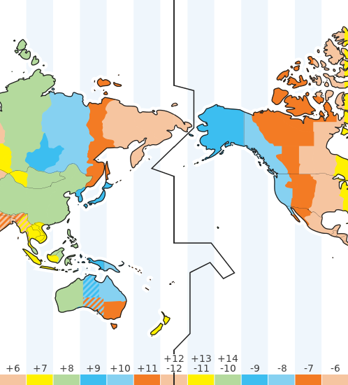
The international date line. Note that the time zones shown are as of January 2012. Go to the Time Zone Map for an up-to-date map showing current time zones and local times.

The International Date Line

The International Date Line (IDL) is an imaginary line of longitude on the Earth’s surface located at about 180 degrees east (or west) of the Greenwich Meridian.
The date line is shown as an uneven black vertical line in the Time Zone Map above and marks the divide where the date changes by one day. It makes some deviations from the 180-degree meridian to avoid dividing countries in two, especially in the Polynesia region.
The time difference between either side of the International Date Line is not always exactly 24 hours because of local time zone variations.
Interactive Time Zone Map
If you travel around the world, changing standard time by one hour each time you enter a new time zone, then a complete circuit would mean that you adjusted your clock or watch time by 24 hours. This would lead to a difference of one day between the date on your clock and the real calendar date. To avoid this, countries are on either side of the International Date Line which runs down the middle of the Pacific Ocean. If you cross the date line moving east, you subtract a day, whereas if you are moving west you add a day.

While the world is divided into 24 time zones, there has to be a place where there is a difference in days, somewhere the day truly "starts" on the planet. Thus, the 180° line of longitude, exactly one-half way around the planet from Greenwich, England and 0° longitude is approximately where the International Date Line is located. Cross the line from the east to the west and a day is added. Cross from west to the east and a day is subtracted.
Without the International Date Line, people who travel west around the planet would discover that when they returned home, it would seem as though an extra day had passed. This situation actually happened to Magellan's crew when they returned home after their circumnavigation of the earth.
Here's how the International Date Line works. Let's say you fly from the United States to Japan. Let's suppose you leave the United States on Tuesday morning. Since you're traveling west the time advances slowly thanks to time zones and the speed at which your airplane flies, but once you cross the International Date Line, it's suddenly Wednesday.
On the reverse trip home you fly from Japan to the United States. You leave Japan on Monday morning but as you cross the Pacific Ocean, the day gets later quickly as you cross time zones moving eastward in an airplace. However, once you cross the International Date Line, the day changes to Sunday.
The International Date Line is not a straight line, either. Since its beginning, it has zigzagged to avoid spitting apart countries into two days. It bends through the Bering Strait to avoid placing far northeastern Russia in a different day than the rest of the country. Unfortunately, tiny Kiribati was split. In 1995 the island country of Kiribati decided to move the International Date Line. Since the line is simply established by international agreement and there are not treaties or formal agreements associated with the line, most of the rest of the world followed Kiribati and moved the line on their maps. Most recent maps show the change and you'll see the big panhandle zigzag which keeps Kiribati all within the same day. Now eastern Kiribati and Hawaii, which are located in the same area of longitude, are a whole day apart.

rift

In geology, a rift or chasm is a place where the Earth's crust and lithosphere are being pulled apart[1] and is an example of extensional tectonics.[2]
Typical rift features are a central linear downfaulted segment, called a graben, with parallel normal faulting and rift-flank uplifts on either side forming a rift valley, where the rift remains above sea level. The axis of the rift area commonly contains volcanic rocks, and active volcanism is a part of many, but not all active rift systems.
Major rifts occur along the central axis of mid-ocean ridges, where new oceanic crust and lithosphere is created along a divergent boundary between two tectonic plates.
Failed rifts are where continental rifting began, but then failed to continue to the point of break-up. Typically the transition from rifting to spreading develops at a triple junction where three converging rifts meet over a hotspot. Two of these evolve to the point of seafloor spreading, while the third ultimately fails, becoming an aulacogen.

Types of Mountains

How are mountains formed?
Mountains are formed by slow but gigantic movements of the earth's crust (the outer layer of the Earth).
The Earth's crust is made up of 6 huge slabs called plates, which fit together like a jigsaw puzzle. When two slabs of the earth's crust smash into each other the land can be pushed upwards, forming mountains. Many of the greatest mountain ranges of the world have formed because of enormous collisions between continents.
Did you know?
Earthquakes occur when two plates pushing past each other cause a fracture in the Earth’s crust.
Mountains form in different ways
Sometimes the crust has folded and buckled, sometimes it breaks into huge blocks. In both cases, great areas of land are lifted upwards to form mountains. Other mountains are formed by the earth's crust rising into a dome, or by volcanic activity when the crust cracks open.

What different types of Mountains are there?
There are five basic kinds of mountains:
  1. Fold Mountains (Folded Mountains)
  2. Fault-block Mountains (Block Mountains)
  3. Dome Mountains
  4. Volcanic Mountains
  5. Plateau Mountains
These different types of mountain names not only distinguish the physical characteristics of the mountains, but also how they were formed.
icon Fold Mountains
Fold mountains are the most common type of mountain. The world’s largest mountain ranges are fold mountains. These ranges were formed over millions of years.
Fold mountains are formed when two plates collide head on, and their edges crumbled, much the same way as a piece of paper folds when pushed together.
The upward folds are known as anticlines, and the downward folds are synclines.
Examples of fold mountains include:
  • Himalayan Mountains in Asia
  • the Alps in Europe
  • the Andes in South America
  • the Rockies in North America
  • the Urals in Russia
The Himalayan Mountains were formed when India crashed into Asia and pushed up the tallest mountain range on the continents.
In South America, the Andes Mountains were formed by the collision of the South American continental plate and the oceanic
Pacific plate.
Did you know?
Two Tectonic Plates meet along the Southern Alps. This is called a fault line. The Southern Alps are constantly changing because the Pacific Plate is being pushed down under the Australian Plate and that causes the Alps to rise up.
icon Fault-block Mountains
These mountains form when faults or cracks in the earth's crust force some materials or blocks of rock up and others down.
Instead of the earth folding over, the earth's crust fractures (pulls apart). It breaks up into blocks or chunks. Sometimes these blocks of rock move up and down, as they move apart and blocks of rock end up being stacked on one another.
Often fault-block mountains have a steep front side and a sloping back side.
Examples of fault-block mountains include:
  • the Sierra Nevada mountains in North America
  • the Harz Mountains in Germany
icon Dome Mountains
Dome mountains are the result of a great amount of melted rock (magma) pushing its way up under the earth crust. Without actually erupting onto the surface, the magma pushes up overlaying rock layers. At some point, the magma cools and forms hardened rock. The uplifted area created by rising magma is called a dome because of looking like the top half of a sphere (ball). The rock layers over the hardened magma are warped upward to form the dome. But the rock layers of the surrounding area remain flat.
As the dome is higher than its surroundings, erosion by wind and rain occurs from the top. This
results in a circular mountain range. Domes that have been worn away in places form many
separate peaks called Dome Mountains.
icon Volcanic Mountains
As the name suggests, volcanic mountains are formed by volcanoes.
Volcanic Mountains are formed when molten rock (magma) deep within the earth, erupts, and piles upon the surface. Magna is called lava when it breaks through the earth's crust. When the ash and lava cools, it builds a cone of rock. Rock and lava pile up, layer on top of layer.
Examples of volcanic mountains include:
  • Mount St. Helens in North America
  • Mount Pinatubo in the Philippines
  • Mount Kea and Mount Loa in Hawaii
Find out more about volcanoes
iconPlateau Mountains (Erosion Mountains)
Plateau mountains are not formed by internal activity. Instead, these mountains are formed by erosion. Plateaus are large flat areas that have been pushed above sea level by forces within the Earth, or have been formed by layers of lava. The dictionary describes these as large areas of ‘high levels’ of flat land, over 600 meters above
sea level.
Plateau mountains are often found near folded mountains. As years pass, streams and rivers erode valleys through the plateau, leaving mountains standing between the valleys.
The mountains in New Zealand are examples of plateau mountains

List of tectonic plates


From Wikipedia, the free encyclopedia
Jump to: navigation, search
Global earthquake epicentres, 1963–1998
The 15 major plates
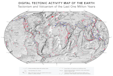
Plate tectonics map from NASA
This is a list of tectonic plates on Earth. Tectonic plates are pieces of the Earth's crust and uppermost mantle, together referred to as the lithosphere. The plates are around 100 km (62 mi) thick and consist of two principal types of material: oceanic crust (also called sima from silicon and magnesium) and continental crust (sial from silicon and aluminium). The composition of the two types of crust differs markedly, with basaltic rocks ("mafic") dominating oceanic crust, while continental crust consists principally of lower density granitic rocks ("felsic"). See also Plate tectonics

Contents

Current plates

The following tectonic plates currently exist on the Earth's surface with roughly definable boundaries.

Primary plates

These seven plates comprise the bulk of the seven continents and the Pacific Ocean.

Secondary plates

These smaller plates are generally shown on major plate maps, but with the exception of the Arabian and Indian plates do not comprise significant land area.

Tertiary plates

Tertiary plates are grouped with the major plate that they would otherwise be shown as part of on a major plate map. Mostly these are tiny microplates, although in the case of the Nubian-Somalian and Australian-Capricorn-Indian plates these are major plates that are rifting apart. Some models identify more minor plates within current orogens like the Apulian, Explorer, Gorda, and Philippine Mobile Belt plates. The remainder of the tertiary plates are the dwindling remains of much larger ancient plates. There may or may not be scientific consensus as to whether a tertiary plate is a separate plate yet, is still a separate plate, or should be considered a separate plate, thus new research could change this list.[1][2][3][4]

Ancient continental formations

In the history of Earth many tectonic plates have come into existence and have over the intervening years either accreted onto other plates to form larger plates, rifted into smaller plates, or have been crushed by or subducted under other plates (or have done all three).

Ancient supercontinents

A supercontinent is a landmass consisting of multiple continental cores. The following list includes the supercontinents known or speculated to have existed in the Earth's past:

Ancient plates and cratons

Not all plate boundaries are easily defined, this is especially true for ancient pieces of crust. The following list of ancient cratons, microplates, plates, shields, terranes, and zones no longer exist as separate plates. Cratons are the oldest and most stable parts of the continental lithosphere and shields are the exposed area of a craton(s). Microplates are tiny tectonic plates, terranes are fragments of crustal material formed on one tectonic plate and accreted to crust lying on another plate, and zones are bands of similar rocks on a plate formed by terrane accretion or native rock formation. Terranes may or may not have originated as independent microplates since a terrane may not contain the full thickness of the lithosphere.

African plate

Antarctica plate

Eurasian plate

Indo-Australian plate

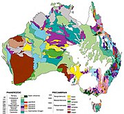
Basic geological regions of Australia, by age.
Map of chronostratigraphic divisions of India

North American plate

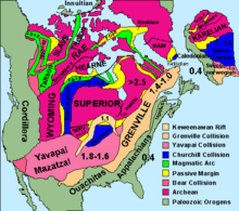
North American Cratons and basement rocks.

South American plate

Plate Tectonics

Intro to Plate Tectonic Theory

animation of breakup of Pangaea Plate tectonics is the theory that Earth's outer layer is made up of plates, which have moved throughout Earth's history. The theory explains the how and why behind mountains, volcanoes, and earthquakes, as well as how, long ago, similar animals could have lived at the same time on what are now widely separated continents.
You probably wouldn't recognize the Earth if you could see it 225 million years ago. Back then, all the major continents formed one giant supercontinent, called Pangaea.
Perhaps initiated by heat building up underneath the vast continent, Pangaea began to rift, or split apart, around 200 million years ago. Oceans filled the areas between these new sub-continents. The land masses continued to move apart, riding on separate plates, until they reached the positions they currently occupy. These continents are still on the move today.
Cross-sectional view of Earth, showing mantle, convection currents, and plate motion
Exactly what drives plate tectonics is not known. One theory is that convection within the Earth's mantle pushes the plates, in much the same way that air heated by your body rises upward and is deflected sideways when it reaches the ceiling.
Another theory is that gravity is pulling the older, colder, and thus heavier ocean floor with more force than the newer, lighter seafloor.
Whatever drives the movement, plate tectonic activity takes place at four types of boundaries: divergent boundaries, where new crust is formed; convergent boundaries, where crust is consumed; collisional boundaries, where two land masses collide; and transform boundaries, where two plates slide against each other.


egg with cracked shell
Go directly to Plate Tectonics activity
(47K - requires Shockwave)

Take a hard-boiled egg and crack its shell. Does the egg remind you of anything? The Earth, perhaps? The egg could be seen as a tiny model of the Earth. The thin shell represents the Earth's crust, divided into plates; within the shell is the firm but slippery mantle. Move the pieces of shell around. Notice how the shell buckles in some places and exposes "mantle" in other places. The same thing happens on Earth, but on Earth, this activity results in the formation of mountains, earthquakes, and new ocean floor.
Even though the theory of continental drift was proposed in 1912 by Alfred Wegener, the idea of moving continents wasn't generally accepted until the early 1960s. That's when Wegener's theory was resurrected by Harry Hess, Robert Dietz, Fred Vine, and Drummond Matthews. The ensuing theory, known as plate tectonics, has had a major impact on Earth Sciences. It represents a scientific revolution as significant to geology as relativity was to physics.
This activity lets you manipulate tectonic plates. Pull the plates apart and push them together and watch what happens to the Earth.

http://www.pbs.org/wgbh/aso/tryit/tectonics/shockwave.html

screen grab of Mountain Maker, Earth Shaker
Text Version of Mountain Maker, Earth Shaker
Build mountains. Trigger volcanoes. Create new sea floor. You now have the power to change the landscape with the slightest push of your mouse. Four types of plate tectonic activity are demonstrated in this feature. Keep an eye on the map to see where in the world the activity takes place.

Divergent Boundary
Also known as spreading boundary, a divergent boundary occurs where two plates move apart, allowing magma, or molten rock, to rise from the Earth's interior to fill in the gap. The two plates move away from each other like two conveyor belts moving in opposite directions.
For more on divergent boundary, go to The Sea Floor Spread.

Convergent Boundary
Also known as subduction boundary, a convergent boundary occurs where one plate slides under another as the two are pushed together. If there is land at the edge of one of these plates, the ocean plate will subduct, or slide under that plate.
For more information, go to The Continental Slide.


Collisional Boundary
A collisional boundary occurs where two land masses on plates are pushed together. Trying to occupy the same space, the land masses buckle and fold, creating mountain ranges.
For more information, go to The Continental Crush.


Transform Boundary
A transform boundary occurs where two plates slide against each other. But rather than sliding smoothly, the plates build up tension, then release the tension with a spurt of movement. This movement is felt as an earthquake.
For more information, go to Slippin' and a Slidin'.

The Sea Floor Spread

Map that shows the Earth's divergent margins, all connected
The Earth's longest mountain chain isn't the Andes in South America, or the Himalayas in Asia, or even North America's Rockies. It's an underwater chain of mountains 47,000 miles long. The chain runs down the middle of the Atlantic Ocean (surfacing at Iceland), around Africa, through the Indian Ocean, between Australia and Antarctica, and north through the Pacific Ocean.
Running along the top of this chain of mountains is a deep crack, called a rift valley. It is here that new ocean floor is continuously created.

Gif Animation, endless loop: wide view of divergent margin, show magama filling gap made my the two separating plates.
As the two sides of the mountain move away from each other, magma wells up from the Earth's interior. It then solidifies into rock as it is cooled by the sea, creating new ocean floor.
The speed at which new ocean floor is created varies from one location on the ocean ridge to another. Between North America and Europe, the rate is about 2.2 inches (3.6 cm) per year. At the East Pacific rise, which is pushing a plate into the west coast of South America, the rate is 12.6 inches (32.2 cm) per year.


The Continental Slide


Gid Animation, endless loop: side veiw of convergent margin showing a trench and a volcanoe
New crust is continually being pushed away from divergent boundaries (where sea-floor spreading occurs), increasing Earth's surface. But the Earth isn't getting any bigger. What happens, then, to keep the Earth the same size? The answer is subduction.
In locations around the world, ocean crust subducts, or slides under, other pieces of Earth's crust. The boundary where the two plates meet is called a convergent boundary. Deep trenches appear at these boundaries, caused by the oceanic plate bending downward into the Earth.
Deep below the Earth's surface, subduction causes partial melting of both the ocean crust and mantle as they slide past one another. This melting generates magma that makes its way to the surface, producing volcanoes, such as Mt. St. Helens. Most of the subducting plate continues into the mantle, perhaps to reappear much later at a distant divergent boundary.

The Continental Crush


GIF Animation, endless loop: side view of collisional margin
An ocean floor pushed toward a land mass will always slide under the land mass. This is because the land mass is more buoyant, or lighter, than the ocean floor. When two land masses meet, on the other hand, neither will slide under the other. Instead, the two crush together at what is known as a collisional boundary. They crumple and fold. Some pieces of land are thrust over or under other pieces. The result is a mountain range.
The Himalayas, the highest mountains in the world, were created this way. (In fact, they're still growing.) So were the European Alps. Even the Appalachian Mountains formed when two land masses came together. Although with the Appalachians, the crushing ended long ago -- all that's left now are the eroded remnants of a once high mountain range.
 Slippin' and a Slidin'


GIF Animation, endless loop: side view of transform boundary
Transform boundaries neither create nor consume crust. Rather, two plates move against each other, building up tension, then releasing the tension in a sudden and often violent jerk. This sudden jerk creates an earthquake.
The San Andreas Fault is undoubtedly the most famous transform boundary in the world. To the west of the fault is the Pacific plate, which is moving northwest. To the east is the North American Plate, which is moving southeast.
Los Angeles, located on the Pacific plate, is now 340 miles south of San Francisco, located on the North American plate. In 16 million years, the plates will have moved so much that Los Angeles will be north of San Francisco!

Thursday, September 20, 2012

who devided india

Who divided India?
November 29, 2006

Historian Stanley Wolpert's new book -- Shameful Flight -- revisits Partition, and lays the blame for one of the most horrific episodes of the 20th century squarely on the shoulders of a Briton, finds Arthur J Pais.

Admiral Louis Francis Albert Victor Nicholas 'Dickie' Mountbatten, the favourite cousin of British King George VI, was famous for his charm. His sycophants in England called it irresistible. His admirers in the British government even thought of him as a statesman who could charm discontented nationalist leaders of the British Empire, and tease out of them agreements that seemed impossible for other British diplomats to obtain.
So Mountbatten was sent to a deeply restive, increasingly riotous and ceaselessly rebellious India in March 1947 as Britain's viceroy, to hammer agreements that could allow the British to withdraw from the subcontinent with dignity -- leaving the country unified.
'Mountbatten viewed the prospect of ruling India during the Raj's sunset year as challenging as a hard-fought polo game, as he put it the King -- 'The last Chukka in India -- 12 goals down,' writes historian Stanley Wolpert in his riveting, disturbing and provocative book, Shameful Flight: The Last Years of the British Empire in India.
"It was a task for only a person of deep insights into India," says Wolpert -- considered by many to be one of the best historians writing on the subcontinent -- in a telephone interview from Los Angeles. "The mission needed a person of great diplomatic skills and [one] who absolutely lacked arrogance."
The British wanted to leave India by 1948 but Mountbatten cut the time by half
November 29, 2006

What Wolpert would discover some 55 years after the Partition of India -- and the concomitant fleeing of more than 10 million Hindus, Muslims, and Sikhs from one side to another -- was so horrifying that the 79-year-old historian might have had a hard time believing it. Mountbatten was not only totally inept at dealing with fractious Indian political parties, Wolpert writes, he hastened the process of Independence. The British government wanted to leave India by 1948 but Mountbatten cut the time by half to mid-August 1947 because he was impatient to get back to England and build his naval career.
Much of it had to do with vindicating his father's reputation.
First Sea Lord of the Royal Navy Prince Louis of Battenberg was forced to resign from the fleet during World War I because of his German origin. The family changed the last name to Mountbatten to avoid further vilification. His then 14-year-old son resolved to join the navy and remain in it until he became First Sea Lord.
"So Mountbatten resolved to make fast work of his India job," Wolpert says. "The British cabinet gave him a longer time, but he never had any intention of using it."
Cloak and dagger
Worse, Mountbatten kept the Partition maps of Punjab and Bengal -- with the Muslim areas of the two provinces going to the newly created Pakistan -- secret, until it was opportune for him to make the announcement.
'Mountbatten had resolved to wait until India's Independence Day festivities were all over,' Wolpert writes, 'the flashbulb photos all shot and transmitted worldwide, Dickie's medal-strewn white uniform viewed with admiration by millions, from Buckingham and Windsor palaces to the White House. What a glorious charade of British imperial largesse and power 'peacefully' transferred.'
Image: At the conference in New Delhi where Lord Louis Mountbatten disclosed Britain's Partition plan for India. (Left to right) Jawaharlal Nehru, Mountbatten's adviser Lord Ismay, Mountbatten and Mohammed Ali Jinnah.
Photograph: Keystone/Getty Images
Wolpert puts quite a bit of blame for Partition at many Indian leaders, including Nehru
November 29, 2006

In his book published by Oxford University Press -- and which reads in parts like fine detective fiction -- Wolpert has directed quite a bit of blame for Partition at many Indian leaders, including Jawaharlal Nehru, Independent India's first prime minister. One of the reasons for the Labour government in Britain, which had come to power soon after World War II, to grant hasty independence to India was because there was hardly any trust between the Labour and Indian leaders, Wolpert argues.
"There were many Left-leaning Labour leaders who thought their proposals for a gradual transfer of full power to India were not appreciated by Indian leaders," Wolpert says.
"They felt Indian leaders were not being grateful, not appreciating the efforts Labour was putting in to end the colonial rule, unlike the Tories led by (Winston) Churchill."
Many of Wolpert's finger pointing is bound to cause debate and controversy. Already, Professor Ainslee Embree of Columbia University has called the book 'engrossing, but very controversial.'
Dilip Basu, professor at the University of California, Santa Cruz, while calling the book 'a delightful read,' added: 'It will be of great interest to anyone curious about whatever happened to the great British Empire and those who often wonder why Indians and Pakistanis endlessly fight with each other.'
Image: Jawaharlal Nehru speaks to Lady Edwina Mountbatten during a display given by the New Delhi Glider Club. On the right, Lady Pamela, daughter of Nehru's guest. 


'Mountbatten was the worst viceroy of India, he was the centerpiece of this tragedy'
November 29, 2006

The central villain in the book is undoubtedly the arrogant and unrealistic Mountbatten. "Partition maps revealing the butchered boundary lines drawn by Sir Cyril Radcliffe," Wolpert says, "through the Sikh heartland of Punjab and the east of Calcutta in Bengal, were kept under lock and key on Mountbatten's orders."
Radcliffe, a barrister, had never set foot on Indian soil before 1947. "He was to accomplish, in a month, work that should have taken at least a year," Wolpert points out. "He was so afraid of what he had done -- worried that Sikhs, Hindus or Muslims would kill him -- (that) he left India hastily."
Wolpert says had the governors of Punjab and Bengal known about the way the two provinces were being partitioned, "they could have, with their early knowledge, saved countless lives by dispatching troops and trains to what would soon become the lines of fire and blood.
"The rapid departure of the British from the region was the catalyst for over half a century of violence, a legacy that lives on today," the historian says, discussing why Partition still holds interest for him.
"The Indian leaders as well as their counterparts in England failed to appreciate how bad and how weak a viceroy Mountbatten was," Wolpert continues. "In many ways, he was the worst viceroy of India, he was the centerpiece of this tragedy."


Churchill called the time limit a 'guillotine'
November 29, 2006

Shameful flight The failure of the British government to see the larger picture and Mountbatten's preoccupation with his career created explosive conditions made worse by the warring Indian leaders, he says.
"I still wonder how it was possible for the leaders of Great Britain, barely two years after defeating, with American support, the armies of Hitler and Mussolini, to withdraw 14,000 British officers in such unseemly haste from India," he adds.
Churchill, who was bitterly opposed to an independent India, cautioned against the sudden departure. He thought the original 14-month schedule was too hasty. His opposition 'could be counted as one of history's supremely ironic moments,' writes Wolpert.
'How can one suppose that the thousand year-gulf that yawns between Muslim and Hindu would be bridged in 14 months?' Churchill asked. He called the time limit a 'guillotine,' adding that the hasty exit could bring a terrible name to Britain. The 'shameful flight' could result in chaos and carnage. 'Would it not be a world crime,' he asked, 'that would stain our good name for ever?'
He warned it would be a 'shameful flight, by a premature hurried scuttle.'

Wolpert sees parallels between the aftermath of 9/11 and what happened in India in 1947
November 29, 2006

Even the eventual founder of Pakistan Mohammad Ali Jinnah, who would not give up his demand for an independent Muslim State, was worried over the way the Partition was being rushed. Wolpert, professor of history emeritus at the University of California, Los Angeles, dedicates his newest book 'To the memory of the millions of defenseless Hindu, Muslim, and Sikh victims of the British India's Partition.'
"For half a decade, I have pondered the question of the tragedy of Partition, and I have dealt with it in some form or the other in many of my books," Wolpert says. "I have also been trying to understand the role of the major people involved in Partition."
Wolpert had been thinking of a book exclusively focusing on Partition for many years but, but because of his other assignments, could begin working on it only about six years ago.
"I am glad I waited for," he said from his Los Angeles home on a Sunday afternoon. "After half a century of studying and teaching Indian history and writing 20 books on the subcontinent, I finally got an opportunity to reflect on one of the most momentous events in history."
He sees parallels between the aftermath of 9/11 and what happened in India in 1947. He sees the "same kind of madness, the same kind of arrogance (as in Mountbatten's decisions) in going to war against Iraq."
Petty politics
The infighting between the Indian leaders added to the tension and problems.
Some of them changed their minds too quickly. Jinnah, who complained the British were prepared to give him only a moth-eaten Pakistan -- meaning a country with the partitioned states of Punjab and Bengal -- at one point suddenly told the British he was not averse to the idea of an independent Bengal ruled by a fellow Muslim League leader.


Gandhi sent word to Jinnah that he would not object to Jinnah being the leader of free India instead of Nehru
November 29, 2006

Nehru gets a lot of blame for going with Mountbatten's desire for not just partitioning the country hastily but also for agreeing to divide Punjab and Bengal. Gandhi had refused for seven years, since Jinnah proposed a separate Muslim nation, to support a 'vivisection of the Mother,' arguing 'Muslims can never cut themselves away from their Hindu or Christian brethren. We are all children of the same Mother.'
He was so serious about saving India that he sent word, a few months before Partition, to Jinnah through Mountbatten that he would not object to Jinnah being the leader of free and united India instead of Nehru. But Jinnah -- who always mistrusted the Mahatma, calling him 'wily Gandhi' -- had no use for such overtures.
Nehru is also faulted for not listening to Gandhi in getting Jinnah to mediate in the escalating violence in undivided Kashmir. Gandhi even wondered if holding a plebiscite in Kashmir could end the looming violence there.
Why did Nehru listen so much to Mountbatten?


Nehru had talked about Mountbatten's fatal charm," Wolpert says. "Of course, he was flattering Mountbatten when he said that. But Nehru unfortunately came too much under the influence of Mountbatten, exacerbated by Nehru's education in England. Nehru was charmed by the English upper world, he thought he could trust and work with Mountbatten. "Mountbatten's royal blood appealed as much to the rulers of princely states in India," Wolpert continues, "as his radical views and social charms did to Nehru. His charm was so much Nehru was blinded by it."
Asked if Nehru's relationship with Mountbatten's wife Edwina played a role, the historian says, "It helped him cloud the danger of what Mountbatten was doing."
Wolpert doesn't fight the idea that Partition looked inevitable by 1947, and he understands why Nehru, seeing the way Hindus had been killed in Bengal and Punjab, agreed to the partition of the two provinces.
"But the real solution to any massacre is not to make more violence by drawing a line blindly through a province," the historian points out. 


Years later, Mountbatten would whisper now and then how he had botched up the Independence process
November 29, 2006

Years after Partition, Mountbatten would whisper now and then how he had botched up the Independence process. Nehru 'finally awakened,' and admitted in a letter to the Nawab of Bhopal, a friend, 'Partition came and we accepted it because we thought that perhaps that way, however painful it was, we might have some peace.
'And yet, the consequences of that Partition have been so terrible that one is inclined to think that anything else would have been preferable,' Nehru added.
At the end of his six-year research and writing, Wolpert was looking for a picture for the book's dust jacket. He had gone through hundreds of pictures of Partition. And he had also seen pictures offering glimpses of thousands of people who perished in the tragedy -- some estimates believe over a million were killed.
"Suddenly, I came across an image that encapsulated the tragedy," he says. It is a picture by the well-known photographer Margaret Bourke-White, showing mostly bare-footed refugees going to places they felt would be safe from the communal carnage.
The image of a Sikh man in the same photograph carrying a woman on his shoulders also spoke volumes, Wolpert says. "The picture brought to our attention the fact that these poor, barefoot people with no possessions had to make the perilous journey because of the idiocy and arrogance of those who had a duty to protect them."